So I was around town today and had my camera with me and decided to take some photos to match some that I found and tucked away from The Indiana Historical Society and elsewhere. I tried to make every effort to find the original sources, as most of these images are now part of the State Archives or Library of Congress. Here are some before/after mergers I made.
First is the Hotel Metropole, with the original image found via HistoricIndianapolis.com. This is at the northwest corner of Ohio and Capitol. Today, the hotel no longer exists and the property is owned by the State of Indiana as a a parking lot for State employees. In the background is the Senate Avenue Parking Garage, which is also State property for its employees. The bus station pictured on Ohio Street is the last “hub stop” for most of IndyGo’s downtown east/west bus routes. From HistoricIndianapolis: “After a short period as the Medical College of Indiana, the old institute building became home to the Imperial Hotel from about 1900 until 1914. Being adjacent to the State House, many legislators and others stayed in the hotel for extended periods. Signs promote[d] Turkish Baths and the Imperial Buffet.” From 1914 to 1920, it was known as the Hotel Metropole:
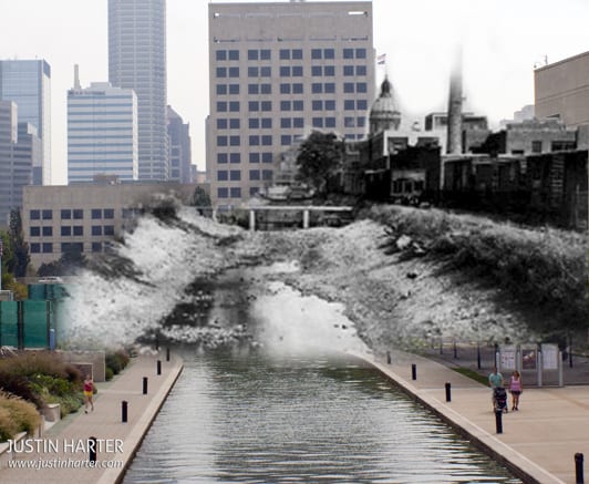
Here is a shot of the Indianapolis Downtown Canal. This shot was taken from what is the new Cultural Trail on the far west end of IUPUI’s campus, just south and west of the Herron School of Art and Design and Military Park. In the original historic photo, most of the background was obscured by a tree, but there were no tall buildings on that end of town at the time that would have been visible. Originally, the canal’s construction was set to connect the Wabash and Erie Canals to the Ohio River. However, Indiana’s attempt to get into the canal construction was halted due to the Panic of 1837 and Indiana’s financial difficulties halted the construction of the $10 million project. It was stopped in 1839 and if it had been completed, would have been part of a central canal that stretched from Peru, Indiana to Evansville, Indiana. Only 8 miles were completed, including partial miles between Anderson and Martinsville, Indiana. Today, the Canal is 1 mile long and connects with various bike and towpaths in Indianapolis. The original photo, taken sometime around the start of the 20th century, is via HistoryCooperative.org:
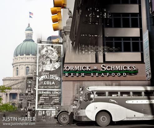
Next is the old Indianapolis Bus Station, located on Illinois Street at Market Street, just one block off Monument Circle to the west. In the background sits the Indiana Statehouse and this property today is home to McCormick and Schmick’s Seafood. Via Shorpy Historical Archive:
Last up is again via HistoricIndianapolis.com, a photo of the 500 Festival Parade in 1947. The band is marching east on West Market Street towards Monument Circle and away from the Indiana Statehouse. Most of the buildings pictured from the past are here today:


Is there any way I could obtain the original photo of the canal in downtown Indianapolis (the second photo)? The website linked in the article doesn’t exist any more. Thanks!